Terms and conditions
IMPORTANT NOTICE
How to use
The Aviation OLS web application allows users to check the maximum permitted height for aviation purposes of any structure at a specific point. NB – The maximum height indicated is the height above the ground (This is NEW in this version). Certain areas on the slopes of the Rock have proved difficult to model and in these cases you will be advised to contact the DCA directly.
Navigate is simple, please observe:
Mouse Left Button + Move: Orbit
Middle button + Move (or mouse wheel): Zoom
Right button + Move: Pan
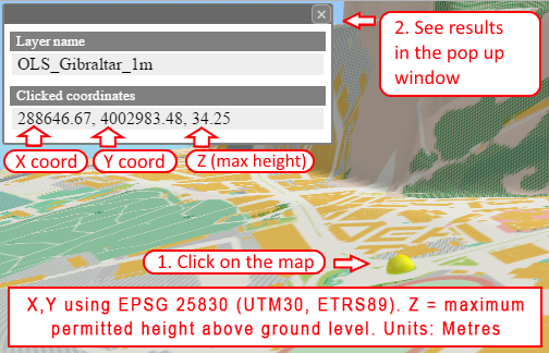
Having navigated to the correct point on the map, click on the point and a pop-up window will appear.In order to be as accurate as possible, you must use a "bird's eye" view when selecting a location to measure.

As can be seen, on the top line of the window the OLS layer name is displayed. On the bottom line the decimal GPS coordinates of the location are displayed and to the right of these coordinates you can find the maximum permitted elevation above ground level for aviation purposes for a structure at that location (see highlighted numbers in the box above).
Town Planning Considerations
Whilst aviation matters are a relevant consideration in the planning process it is only one of many matters that are taken into account when making a decision on whether to grant planning permission. It is therefore possible that the maximum heights quoted for aviation purposes may not be acceptable for planning reasons and that a lower height may be imposed. Developers are encouraged to consult with the Town Planning Department at an early stage in the design process.
Accuracy of Results
However, please note the maximum permitted obstacle heights for aviation purposes are to be used for “guidance purposes only”. Due to the resolution available for display, the map should be considered to have a horizontal accuracy of +- 5 metres and thus the vertical accuracy should be considered as +- 3 metre. For planning applications where the height of the Development is within 3 metres of the maximum permitted height above ground level, then applicants are to provide the DCA with UTM coordinates (EPSG:25830) for the extremities of the building / or site and the DCA, using a different model, will provide the accurate maximum permitted height above ground level.
Please note that as a general rule of thumb the maximum height of buildings on the steep slopes of the Rock for aviation purposes is 30 metres above ground level.
Instructions for Use of the Model
Please note that all elevations are height above ground level at the point selected. Horizontal coordinate system is EPSG:25830 (UTM30, ETRS89). Metres.
Should you have any questions on the use of the model, please contact the Director of Civil Aviation on 20061174
Current View URL
Usage
About
- three.js http://threejs.org/ (LICENSE)
- dat-gui https://code.google.com/p/dat-gui/ (LICENSE)